
Page 19 - Surveyor 50.2 2015
P. 19
Surveying the Condition of a Selected Flat Roof for Possible Water Ponding Defect
Vol.50 No.2 2015
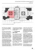
Figure 1: Flat roof layout plan and survey area
600 m2 of flat roof area consisting of 12 measured using a ruler. The findings were a height of 30 mm to 35 mm. There was
points of rainwater downpipe (RWDP). summarised according to the criticality of also a watermark on the flat roof slab
The area involved in the survey is shown each RWDP point, which was scored as near this area at 30 mm. Dirt has been
in Figure 1. low, medium, or high. identified on RWDPs 6 to 8, with the dirt
level reaching 35 mm to 40 mm. Figures
This survey was carried out using visual 4.0 Findings and 8 to 10 show the respective conditions of
inspection. The overview and existing Discussion these flat roof areas.
condition of the survey area was recorded
using a camera. The survey area was It was a sunny day when the survey was The surface areas of the flat roof near
measured using a measuring tape and conducted, although heavy rainfall was RWDPs 9 to 12 do not show water
laser distance meter, and the number of recorded 10 hours before the survey was ponding. However, dirt and mold growth
RWDP was recorded. Figure 2 shows the conducted. During the visual inspection, has been identified in these areas. This
survey area and overview of the existing water ponding and watermarks have finding can be attributed to the stagnant
condition of the flat roof. The number of been identified on several areas of the flat water trapped at the surrounding RWDP
RWDP points is also labeled in Figure 2. roof surface. Dirt has been identifiedon points, which creates deposits of dirt. Dirt
the gutters, and the dirt level reached level in this area reached 25 mm to 35
General building inspection was carried 25 mm to 35 mm. However, there is no mm. This area shows the water ponding
out to determine the existing condition of water ponding on the surface area of the effect, ecause the area is near the water
the flat roof and to identify any possibility flat roof near RWDPs 1 to 5, as shown in tank blocked by direct sunlight. Figures 11
of water ponding and watermark on Figures 3 to 7, respectively. to 14 show the respective conditions of
the flat roof surface. It also aimed to these flat roof areas.
determine the presence of dirt around Water ponding has also been identified on
the cages of RWDPs, which might cause the flat roof surface near RWDPs 6 and 8. Based on the observations on the next
water ponding on the flat roof surfaces. Water ponding level on this area reached page, water ponding that occurs in this
The height of water ponding and dirt were flat roof area is caused by deposited
19