
Page 25 - Surveyor 54.3 and 4
P. 25
The Potential of Panoramic Images for 3D Indoor Model Reconstruction
Vol.54 No.3 & 4 2019
reconstruction in the form of digital
3D models within the information
system, as their development
progresses “by leaps and bounds”
(Luhmann, 2010).
According to Hanke & Grussenmeyer
(2002), panorama images can be
acquired quite easily by any type of
modern digital camera. However,
special notice must be given to
geometric camera calibration
if precise panoramas and/or
photogrammetric products shall be
achieved. In addition to standard
calibration parameters, panorama
adapters must be adjusted in order
to ensure alignment of the rotation
axis and the perspective centre
of the camera. The mathematical
model of panorama images
is usually based on cylindrical
coordinates. Since collinearity
equations can be derived easily,
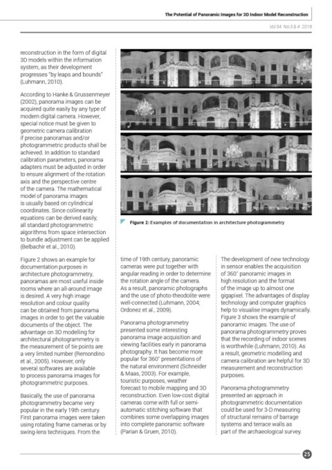
all standard photogrammetric Figure 2: Examples of documentation in architecture photogrammetry
algorithms from space intersection
to bundle adjustment can be applied
(Belbachir et al., 2010).
Figure 2 shows an example for time of 19th century, panoramic The development of new technology
documentation purposes in cameras were put together with in sensor enables the acquisition
architecture photogrammetry, angular reading in order to determine of 360˚ panoramic images in
panoramas are most useful inside the rotation angle of the camera. high resolution and the format
rooms where an all-around image As a result, panoramic photographs of the image up to almost one
is desired. A very high image and the use of photo-theodolite were gigapixel. The advantages of display
resolution and colour quality well-connected (Luhmann, 2004; technology and computer graphics
can be obtained from panorama Ordonez et al., 2009). help to visualise images dynamically.
images in order to get the valuable Figure 3 shows the example of
documents of the object. The Panorama photogrammetry panoramic images. The use of
advantage on 3D modelling for presented some interesting panorama photogrammetry proves
architectural photogrammetry is panorama image acquisition and that the recording of indoor scenes
the measurement of tie points are viewing facilities early in panorama is worthwhile (Luhmann, 2010). As
a very limited number (Remondino photography. It has become more a result, geometric modelling and
et al., 2005). However, only popular for 360˚ presentations of camera calibration are helpful for 3D
several softwares are available the natural environment (Schneider measurement and reconstruction
to process panorama images for & Maas, 2003). For example, purposes.
photogrammetric purposes. touristic purposes, weather
forecast to mobile mapping and 3D Panorama photogrammetry
Basically, the use of panorama reconstruction. Even low-cost digital presented an approach in
photogrammetry became very cameras come with full or semi- photogrammetric documentation
popular in the early 19th century. automatic stitching software that could be used for 3-D measuring
First panorama images were taken combines some overlapping images of structural remains of barrage
using rotating frame cameras or by into complete panoramic software systems and terrace walls as
swing-lens techniques. From the (Parian & Gruen, 2010). part of the archaeological survey.
25